ISO 19160-1:2015 Addressing - Part 1: Conceptual model
Overview
| Full name | ISO 19160-1:2015, Addressing - Part 1: Conceptual model |
| Version | Draft International Standard (DIS) |
| Amendments | None |
| Corrigenda | None |
| Published by | ISO/TC 211 |
| Languages | English |
| Online overview | https://www.iso.org/obp/ui/#iso:std:iso:19160:-1:ed-1:v1:en |
| Derived ontologies | https://github.com/ISO-TC211/GOM/tree/master/isotc211_GOM_harmonizedOntology/19160-1/2015 |
| Type of standard | ISO International Standard Application level |
| Application | The standard is implemented by developing a profile of the ISO 19160-1 conceptual model. It facilitates communication about addresses and interoperability between address specifications; for example, in the cross mapping of conceptual models between different address specifications. |
| Conformance classes | Model – Core Model – Lifecycle Model – Provenance Model – Locale Model – Full conformance Address profile documentation |
| Fundamental geographic dataset | Category: Administration and spatial organisation Data Theme: Land management units/areas |
Scope
ISO 19160-1 defines a conceptual model for address information (address model), together with the terms and definitions that describe the concepts in the model. Lifecycle, metadata and address aliases are included in the conceptual model. The model is presented in UML.
The model provides a common representation of address information, independent of actual addressing implementations. It is not intended to replace conceptual models proposed in other specifications, but provides a means to cross-map between different conceptual models for address information and enables the conversion of address information between specifications.
The model provides a basis for developing address specifications by individual countries or communities.
Implementation benefits
Addresses are one of the most common ways to unambiguously determine an object for purposes of identification and location. Address reference systems vary from country to country: in many Euro-centric countries reference to a road network in the address is common, while addresses in countries such as Japan and South Korea (though South Korea is moving away from this) comprise a hierarchy of administrative areas without reference to a thoroughfare. Addresses are used for a wide variety of purposes: postal delivery, emergency response, customer relationship management, land administration, utility planning and maintenance, to name a few. ISO 19160-1 provides a formal mechanism to describe conceptual models in addressing. It facilitates communication about addressing with a set of addressing terms defined in the standard.
A variety of address standards and/or specifications are in use around the world, described in the report of the preparatory work for this ISO standard, the Review summary of the ISO 19160 stage zero project (2011). These standards and specifications are well integrated into various operational processes and in some cases legally enforced. At the same time, some countries are rationalising their addressing system or creating a new one. Due to developments in ICT, addresses are increasingly used to reference new geographic objects (e.g. road furniture), while they are also increasingly used in new technology, such as in-vehicle navigation. ISO 19160-1 does not replace any standards and specifications, but rather aims to facilitate interoperability between existing and future address specifications. It facilitates the development of addressing tools, for example, software and utilities to assign and maintain addresses, and web services for query and retrieval of address information.
Implementation guidelines
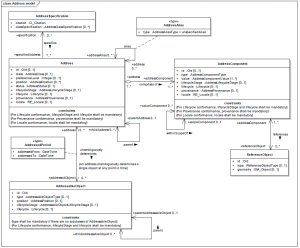
An address is structured information that allows the unambiguous determination of an object (the addressed object) for purposes of identification and location. A set of addresses unambiguously determining the same object are called address aliases. Examples are colloquial, lifecycle and locale aliases.
Address components, e.g. address number, thoroughfare name and place name, are combined to form an address. An address reference system defines the rules for combining address components into addresses. A set of addresses that share the same address components, operations, methods, relationships, and semantics are collectively referred to as an address class.
An address component may have alternative values, for example, ‘Jozi’ and ‘Joburg’ are colloquial forms of ‘Johannesburg’. Other alternatives are abbreviations (‘St’ and ‘Street’) or alternatives in different languages (‘Köln’ and ‘Cologne’). The address component may reference (an)other object(s), for example, a thoroughfare name component may reference a set of street centre line segments, a place name component may reference an administrative area boundary or a municipality name may reference an object with non-spatial attributes.
The address model in ISO 19160-1 defines classes and associations for the representation of addressing information. Figure 10.11 provides an overview of the address model. From this a profile for a specific country, region or purpose can be developed. Profiles of ISO 19160-1 will be published at http://standards.iso.org/iso/19160/-1/.
The first five conformance classes in ISO 19160-1 concern the address model:
- An address model conforming to ‘Model – Core’ appropriately includes the specified classes, attributes and associations.
- An Address, AddressComponent or AddressableObject class conforming to ‘Model - Lifecycle’ includes the relevant lifecycle attributes and its unique identifier attribute is mandatory.
- An Address or AddressComponent class conforming to ‘Model - Provenance’ includes the relevant provenance attributes.
- An Address, AddressComponent or AddressComponentValue class conforming to ‘Model - Locale’ includes the relevant provenance attributes.
- An address model conforming to ‘Model – Full’ passes the conformance tests specified for the above four conformance classes.
A sixth conformance class is specified for the documentation of an address profile. Conformant documentation meets the documentation requirements specified in the standard, amongst others, the documentation includes reference to the address specification represented in the model, diagrams with the relevant classes, types, codelists and associations, a bi-directional mapping between addresses in the address specification and the profile, and diagrams of instance data. Some of the profile examples in the annexes of ISO 19160-1 meet the requirements specified for the ‘Address profile documentation’ conformance class.
See also
- ISO 19107:2003 Geographic information - Spatial schema
- ISO 19152:2012 Geographic information - Land Administration Domain Model (LADM)
