ISO 19152:2012 Geographic information - Land Administration Domain Model (LADM)
Overview
| Full name | ISO 19152:2012, Geographic information - Land Administration Domain Model (LADM) |
| Version | Edition 1 |
| Amendments | None |
| Corrigenda | None |
| Published by | ISO/TC 211 |
| Languages | English |
| Online overview | Not available yet |
| Type of standard | ISO International Standard Application level |
| Application | The land administration domain model provides a formal mechanism for describing land administration data, such as cadastral and deeds data. It is implemented by developing an application schema or profile of the LADM model. It provides an extensible basis for the development and refinement of efficient and effective land administration systems, based on a Model Driven Architecture (MDA), and enables involved parties, both within one country and between different countries, to communicate, based on the shared vocabulary (that is, an ontology), implied by the model. The latter is required for the sharing and exchange of data. |
| Conformance classes | Party – Level 1, Level 2 and Level 3 Administrative – Level 1, Level 2 and Level 3 Spatial Unit – Level 1, Level 2 and Level 3 Surveying and Representation – Level 1, Level 2 and Level 3 |
| Fundamental geospatial dataset | Category: Administration and spatial organisation Data Theme: Land management units/areas |
Scope
- ISO 19152:2012
- defines a reference Land Administration Domain Model (LADM) covering basic information-related components of land administration (including those over water and land, and elements above and below the surface of the earth);
- provides an abstract, conceptual model with four packages related to parties (people and organisations); basic administrative units, rights, responsibilities, and restrictions (ownership rights); spatial units (parcels, and the legal space of buildings and utility networks); spatial sources (surveying), and spatial representations (geometry and topology);
- provides terminology for land administration, based on various national and international systems, that is as simple as possible in order to be useful in practice. The terminology allows a shared description of different formal or informal practices and procedures in various jurisdictions;
- provides a basis for national and regional profiles; and
- enables the combining of land administration information from different sources in a coherent manner.
Implementation benefits
Land administration systems have in common that they are concerned with the relationships between people and land, and the description of rights (e.g. ownership or use) over the land. Over the past decades there has been a consistent move to digital land administration systems and these systems are widely influenced by developments in information and communication technology (ICT). Two common functions of all land administration systems are to keep the contents of the relationships up-to-date and to provide information from the system.
ISO 19152:2012 facilitates the development of tools that are usable by any land administration system conforming to ISO 19152:2012; for example, software and utilities to capture and update land administration information and web services for query and retrieval of land administration information.
Most countries have developed land administration systems to suit their own specific circumstances. For example, one country may have a deeds registration system, another a title registration system. Some systems are centralised, others decentralised. Some systems are based on a general boundaries approach, others on fixed boundaries. Some systems have a fiscal background, others a legal one. These different approaches and implementations hinder meaningful communication across borders. Implementing ISO 19152:2012 not only facilitates verbal communication and understanding, it also allows one to exchange land administration data or aggregate data from different sources.
Implementation guidelines
Land administration refers to the process of determining, recording and disseminating information about the relationship between people and land. It is a wide field; the focus in ISO 19152:2012 is on land administration concerned with rights, responsibilities and restrictions affecting land (or water), and the geometrical (geographic) components thereof.
Land administration systems are concerned with geographic data (e.g. land parcel boundaries), as well as with non-spatial data, such as information about people and relationships among people. In some jurisdictions, the relationship between people and land, e.g. the ownership right to land, has legal status. Such rights are often registered with the purpose of assigning legal meaning to the registered right.
The land administration domain model (LADM) is a conceptual model. Implementation of LADM requires the development of an application schema, such as a country profile. The LADM is generic, but expandable. It is very likely that additional attributes, operators, associations and classes, are needed for a specific regional or country profile. A variety of profile examples are included in the informative annexes of ISO 19152:2012. Representation of land administration related data, such as address data, taxation data, land use data, land cover data, valuation data, physical utility network data and archive data are not within the scope of the LADM. However, LADM provides guidance on how such data may be represented and linked to the LADM.
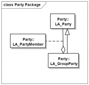
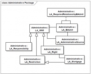
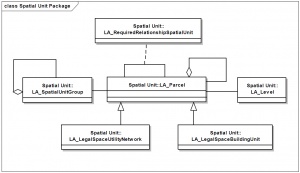
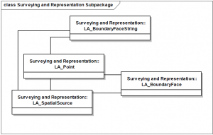
The LADM is organised into three packages (Party, Administrative and SpatialUnit) and one sub package (Surveying and Representation). A (sub)package groups related classes into a single unit. The model is represented in UML. Figures below provide an overview of the main classes and associations in the four packages.
The Party package contains classes representing information about a person or organisation with a relationship to land. This can be a party or a group party. A group party is a number of parties together forming a distinct entity in the context of land administration.
The classes in the Administrative package represent the rights, restrictions and responsibilities associated with a basic administrative unit, i.e. one or more spatial units against which a homogeneous right or restriction can be registered or recorded. The administrative source provides the evidence for these rights, restrictions and responsibilities, for example, a document describing the property transaction (deed).
The Spatial Unit package contains classes representing an area of land and/or water or a volume of space, as well as the relationships between them. A land parcel is defined as an alias for a spatial unit. Spatial units are structured to support creation and management of basic administrative units. They may be grouped hierarchically in two ways. Firstly, spatial units can be aggregated into spatial unit groups. For example, all land parcels in a municipality could be grouped into a spatial unit group. Secondly, a spatial unit can be an aggregation of sub-units. For example, a land parcel, which is a group of sub parcels created by subdivisions.
The classes in the Surveying and Representation package represent information about surveys and point, line and surface representations of spatial units (LA_Point, LA_BoundaryFaceString, LA_BoundaryFace). A survey is documented with one or more spatial sources, such as a registered survey plan or aerial photograph. Point, line and surface representations can be acquired in the field (e.g. with classical surveys or through the GNSS), or be compiled from other sources, such as field sketches and orthophotos. The representations of spatial data conform to the spatial schema described in ISO 19107:2003 Geographic information - Spatial schema.
An application schema, such as a regional or country profile, may conform to ISO 19152:2012 at one of three levels for one or more of the packages and sub packages. The content of a conformant dataset corresponds to an application schema conforming to ISO 19152:2012 (for the relevant packages and levels).
Level 1, 2 and 3 compliance requires the relevant classes of a package to pass the conformance tests specified for those classes in ISO 19152:2012. For example, the following table lists the classes indicated as level 1 in the different packages. If the classes in an application schema pass all the tests specified in ISO 19152:2012 for the Party, Administrative and Spatial Unit classes in the table below, the model is said to be Level 1 conformant for the Party, Administrative and Spatial Unit packages. An example of such a conformance test for LA_Party is to ensure that the application schema contains at least one class conforming to the definition of LA_Party and has all mandatory attributes and association roles of LA_Party specified in ISO 19152:2012. Conformance tests are performed by examining the application schema.
Classes indicated as level 1 in the LADM
| Package | Level 1 classes |
|---|---|
| - | Versioned Object |
| - | LA_Source |
| Party | LA_Party |
| Administrative | LA_RRR |
| Administrative | LA_Right |
| Administrative | LA_BAUnit |
| Administrative | LA_AdministrativeSource |
| Spatial Unit | LA_SpatialUnit |
See also
- ISO 19107:2003 Geographic information - Spatial schema
- ISO 19160-1:2015 Addressing - Part 1: Conceptual model
- ISO 14825:2011 Intelligent transport systems - Geographic Data Files (GDF) - GDF5.0


