ISO 19159-1:2014 Geographic information - Calibration and validation of remote sensing imagery sensors - Part 1: Optical sensors
Overview
| Full name | ISO 19159-1:2014, Geographic information - Calibration and validation of remote sensing imagery sensors - Part 1: Optical sensors |
| Version | Edition 1 |
| Amendments | None |
| Corrigenda | None |
| Published by | ISO/TC 211 |
| Languages | English |
| Online overview | https://www.iso.org/obp/ui/#iso:std:iso:ts:19159:-1:ed-1:v1:en |
| Type of standard | ISO Technical Specification Application level |
| Application | The specification defines the service metadata for the calibration procedures of optical remote sensing sensors, as well as the associated data types and code lists. Such information is useful for the evaluation of the quality of images recorded by sensors. Future parts of this specification will specify calibration and validation for other types of sensors. |
| Conformance classes | Project OpticsSensor: Geometry OpticsSensor: Radiometry OpticsCalibrationFacility: Geometry OpticsCalibrationFacility: Radiometry OpticsValidation Documentation |
Scope
ISO/TS 19159-1 defines the calibration and validation of airborne and space borne remote sensing imagery sensors.
The term calibration refers to geometry, radiometry and spectral, and includes the instrument calibration in a laboratory as well as in-situ calibration methods.
The validation methods address validation of the calibration information.
ISO/TS 19159-1 also addresses the associated metadata related to calibration and validation that has not been defined in other ISO geographic information standards.
The specified sensors include optical sensors of the type frame cameras and line cameras (2D CCD scanners).
Implementation benefits
Vast amounts of remotely sensed imaging data are collected through a variety of sensors. The images themselves are used as is, but are also frequently used in the preparation of derived geographic datasets, such as, topographic data and digital elevation models. The quality of these geographic datasets depends, amongst others, on the quality of the measuring instruments that originally sensed the images. The quality of the measuring instruments is determined and documented during calibration.
Calibration can be a costly and time-consuming exercise. Therefore, sometimes strategies are devised to combine longer time intervals between subsequent calibrations with simplified intermediate calibration procedures. The simplified intermediate calibrations save on costs and bridge the time gap, while still ensuring a traceable level of quality. ISO/TS 19159-1:2014 refers to these intermediate calibrations as validations.
The quality of a wide variety of geographic datasets depends on the quality of the measuring instruments used to sense images. Sharing information about the calibration and validation of the quality measuring instruments of sensors facilitates the evaluation of the quality of the images. The different parts of ISO/TS 19159-1:2014 specify service and data requirements for the calibration of remote sensing imagery sensors and the validation of the calibration information and procedures. They do not, however, address the validation of the data and the derived products. The first part, ISO/TS 19159-1:2014, is concerned with optical sensors, i.e. airborne photogrammetric cameras and space borne optical sensors. These include digital frame cameras that take 2-dimensional images as a whole, line cameras that apply the pushbroom or whiskbroom principle, as well as sensors that record electromagnetic radiation of the infrared spectrum, such as, thermal, multispectral and hyperspectral cameras.
Implementation guidelines
ISO 19159-1:2014 specifies service and/or data conformance in seven conformance classes:
- Project
- OpticsSensor: Geometry
- OpticsSensor: Radiometry
- OpticsCalibrationFacility: Geometry
- OpticsCalibrationFacility: Radiometry
- OpticsValidation
- Documentation
Service conformance requires the use of an appropriate service interface for the project, sensor, calibration facility and validation respectively. To test conformance, the relevant service interface documentation is verified against the service interface requirements specified in ISO 19159-1:2014.
Data conformance requires an adequate application class for the expression of information about the project, sensor, calibration facility, validation and documentation respectively. To test conformance, the application schema documentation is verified against the requirements specified in ISO 19159-1:2014.
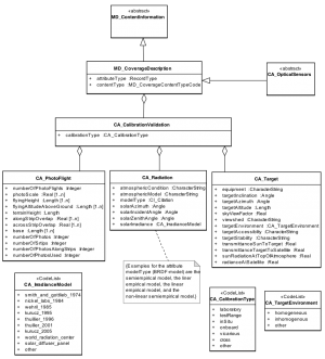
Data and service interface requirements in ISO/TS 19150-1:2012 Geographic information - Ontology - Part 1: Framework are specified in a UML model and associated data dictionary. For example, data conformance for a project requires the application class with information about a project to make use of the three codelists illustrated in Classes with information about calibration and validation, i.e. CA_CalibrationType, CA_TargetEnvironment and CA_IrradianceModel. Note that additional values may be added to a codelist for a specific implementation. As another example, service conformance of the project’s service interface requires it to use the interfaces specified in the CA_CalibrationValidation, CA_PhotoFlight, CA_Radiation and CA_Target classes in Classes with information about calibration and validation.
