ISO 19156:2011 Geographic information - Observations and Measurements
Overview
| Full name | ISO 19156:2011, Geographic information - Observations and Measurements |
| Version | Edition 1 |
| Amendments | None |
| Corrigenda | None |
| Published by | ISO/TC 211 |
| Languages | English, French |
| Online overview | https://www.iso.org/obp/ui/#iso:std:iso:19156:ed-1:v1:en |
| Derived ontologies | https://github.com/ISO-TC211/GOM/tree/master/isotc211_GOM_harmonizedOntology/19156/2011 |
| Type of standard | ISO International Standard Meta level |
| Application | This standard specifies a schema for observations and measurements, including a schema for sampling features. The schema is useful for the exchange of information describing observation acts and their results, both within and between technical and scientific communities. Examples in the natural environment are water quality, seismic, temperature and other weather observations. |
| Conformance classes | Generic observation interchange Measurement interchange Specialized observation interchange Coverage observation interchange Temporal coverage observation interchange Sampling feature interchange Spatial sampling feature interchange Sampling point interchange Sampling curve interchange Sampling surface interchange Sampling solid interchange Specimen interchange |
| Fundamental geographic dataset | Category: Environmental information Data Theme: Natural environment |
Scope
ISO 19156:2011 defines a conceptual schema for observations, and for features involved in sampling when making observations. These provide models for the exchange of information describing observation acts and their results, both within and between different scientific and technical communities.
Observations commonly involve sampling of an ultimate feature-of-interest. ISO 19156:2011 defines a common set of sampling feature types classified primarily by topological dimension, as well as samples for ex-situ observations. The schema includes relationships between sampling features (sub-sampling, derived samples).
ISO 19156:2011 concerns only externally visible interfaces and places no restriction on the underlying implementations other than what is needed to satisfy the interface specifications in the actual situation.
Implementation benefits
ISO 19156:2011 has its origins in the work on Sensor Web Enablement (SWE) undertaken in OGC. SWE is concerned with establishing interfaces and protocols to enable a ‘Sensor Web’ through which applications and services are able to access sensors of all types, and observations generated by them, over the Web. While ISO 19156:2011 has its origins in a Web initiative, it can equally well be used to facilitate the exchange of observations and measurements through other media.
Implementation guidelines
Observation is the act of observing a property. The goal of an observation is to measure or otherwise determine the value of a property. A value is exact if assigned by some authority (e.g. name or price), while a value determined by the application of an observation procedure is an estimate (e.g. height or classification). The observation result – the value – describes a phenomenon or property of a feature, the feature-of-interest of the observation. Observations are often made by an instrument or a sensor, but may also be made by a process chain, human observer, an algorithm, a computation or a simulator. Observation properties provide context or metadata to support evaluation, interpretation and use of the observation results.
The principal location of interest of an observation is usually associated with the ultimate feature-of-interest, but this location is not always trivial to determine (e.g. complex processing is required to geolocate a remotely sensed image) and sometimes the location is of no interest (e.g. observations on non-located chemical species). Therefore, ISO 19156:2011 is flexible about the inclusion of the observation location in an application schema.
ISO 19156:2011 defines a conceptual schema for observations and measurements that may either be used in application schemas, profiles and implementation specifications or be included in a cross-domain application schema. The conceptual schema is represented in UML.
Any application schema conforming to ISO 19156:2011 has to conform to the general rules for application schema specified in ISO 19109:2015 Geographic information - Rules for application schema. In addition, ISO 19156:2011 defines 12 conformance classes for application schemas of observations and measurements that support applications with varying requirements:
- Generic observation interchange
- Measurement interchange
- Specialized observation interchange
- Coverage observation interchange
- Temporal coverage observation interchange
- Sampling feature interchange
- Spatial sampling feature interchange
- Sampling point interchange
- Sampling curve interchange
- Sampling surface interchange
- Sampling solid interchange
- Specimen interchange
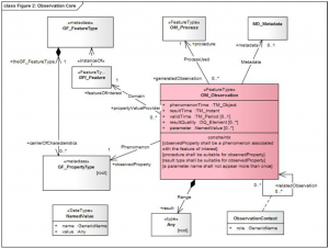
For example, an application schema conforming to the Generic observation interchange conformance class correctly implements the mandatory attributes, associations and constraints specified for the OM_Observation class in the conceptual schema defined in ISO 19156:2011. See figure below. Conformance of an application schema is tested by inspecting the schema’s documentation.
The model for observations in ISO 19156:2011 uses terminology based on current practice in a variety of scientific and technical disciplines. It is designed to apply across disciplines, so the best or ‘most neutral’ term has been used in naming the classes, attributes and associations in the model. The terminology does not, however, correspond precisely with any single discipline. Therefore the use of alternative names for classes and properties is allowed, provided there is a one-to-one mapping to the classes and properties specified in the UML model of the standard. Annex B in the standard provides a mapping from the model element names to common terminology in application domains, such as Earth observations, metrology and chemistry.
See also
- ISO 19109:2015 Geographic information - Rules for application schema
- Observations & Measurements (O&M) - XML implementation
- OGC SensorML: Model and XML Encoding Standard
- OpenGIS Sensor Observation Service Interface Standard
- OGC Sensor Planning Service Implementation Standard
- OGC Sensor Planning Service Interface Standard 2.0 Earth Observation Satellite Tasking Extension
- OpenGIS Sensor Model Language (SensorML)
- OpenGIS Sensor Observation Service
- OpenGIS Sensor Planning Service Application Profile for EO Sensors
- OpenGIS SWE Service Model Implementation Standard
- unofficial description of OGC Observations and Measurements - Simple Feature model & encodings (OMSF)
- OGC Observations and Measurements - GeoJSON Encoding
